sections |
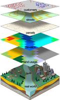
One of the IC^2 projects initiated last year is based on Faculty Development. Our premise is that faculty members who are empowered with new computational tools will be able to utilize these tools in their discipline-specific scholarship/teaching in innovative ways. Given the importance of spatial data processing, we decided to build our efforts on Geographic Information Systems (GIS). For more information on GIS, please refer to our introductory slides or "What is GIS?" by Sinton and Lund. Of course, there is also Wikipedia but we don't want our students to see us use it as a reference. This project is built on three main components, each building on the results of the previous: An introductory computational course centered around GIS. This course will be taught by John Barr (barr@ithaca.edu) in Spring 2012 (Mon/Wed/Fri 9:00-9:50 AM). Application of the acquired knowledge/skills/technology in a discipline specific scholarship project. These projects will be seeded at the end of the Spring course and will be completed within one to two semesters. Application of the acquired knowledge/skills/technology in a discipline specific course. Participation clearly requires a significant investment of time and effort. Therefore, there is a three credit reassigned time associated with involvement. Because there are only three seats reserved for faculty members, we welcome proposals from faculty members who are interested signing up for one of these seats. These proposals are due 9/30/2011 (Friday). Since we can never submit anything on time, it would be hypocritical for us to have no flexibility. Needless to say, 9/30/2011 is a midnight deadline. And, once it is a Friday midnight deadline, it might as well be a Sunday midnight deadline. We did not want to be too prescriptive in our proposal instructions; instead, we chose to explain the goals of our project so that you can provide us with the most suitable information we need to process the applications. With this in mind, if you are interested, please provide short narratives for the following; specifics would be particularly valuable: What drew you to this project? In what way can GIS can add to your scholarship? What venues (journals, conferences, funding agencies, etc) exist in your field for your GIS based scholarship? In what way can GIS add to your teaching? Along with your responses, please email a copy of your CV to Arlene Dende (adende@ithaca.edu). A committee will evaluate the proposals to choose participants that have the most potential for successfully integrating GIS into their scholarship and teaching Please let us know if you have any comments and/or questions.
|
© Copyright Ithaca College. All rights reserved; unauthorized use prohibited. All material on this server is produced by our community but, except for designated pages, is neither approved nor verified by Ithaca College.
 This is the official announcement for submitting applications for faculty participation (with reassigned time) in the Spring 2012 Geographic Information Systems (GIS) course (Comp 12400).